Built Environment
KEY INSIGHTS
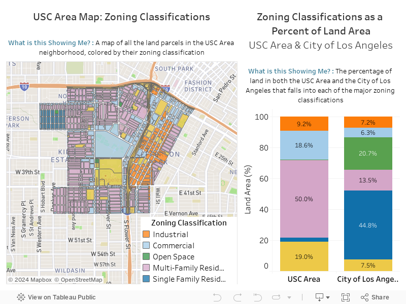
- The USC area has less than 1% of its land zoned for Parks & Open Space, compared to 21% Citywide.
- Nearly half of the land around USC is zoned for Multi-Family Housing, compared to 14% Citywide.
Zoning Classification
Key Takeaways
- Due in part to USC’s presence, the neighborhood containing the university has approximately three times more Commercial zoning than the City at large.
- The USC Area neighborhood also has significantly more land zoned for Public Facilities, including Exposition Park, the Los Angeles Memorial Coliseum/the Banc of California Stadium, Los Angeles Trade Tech College, as well as several K-12 schools.
- The neighborhood around USC has less than 1% of its land zoned for Parks and Open Space, compared to 21% Citywide.
- Nearly half of the land in the neighborhood around USC is zoned for Multi-Family housing, compared to 14% Citywide. Notably, multi-family housing can be built on commercially zoned land. Therefore, nearly 70% of the land near USC can be used to build multifamily housing compared to nearly 20% Citywide.
- Just 3% of the USC Area neighborhood is zoned for Single-Family Housing compared to 45% Citywide.
VARIABLE DEFINITION
Zoning Classification: The classification of land use, and what can be constructed on land
DATA SOURCE
City of Los Angeles
DATA NOTES
More About Zoning Classification: Zoning type determines the makeup of the built environment; the codes are created by city governments to determine how a given extent of land is categorized by zoning type. The most common zoning types are: residential (single-family, multi-family), commercial, industrial, open area, and public facility.